Inverness County Centre for the Arts
Region: Canada’s Musical Coast
Community: Inverness
The Inverness County Centre for the Arts is a regional hub for the arts on the west coast of Cape Breton Island, Nova Scotia. Situated in t...

Length: 30+km (18.8+mi) total
Hiking time: 1-8+hr
Type of Trail: natural surface, compacted earth
Uses (no snow): walking
Uses (snow): snowshoeing
Facilities: interpretive panels
Dog Use: off-leash permitted
Gov’t Topo Map: 11K03 (Lake Ainslie)
Rating (1-5): 4 [steepness]
Trailhead GPS Reference: N 46 08” 31.6’ W 61 26” 48.2’
Access Information: In the village of Mabou, turn off Highway 19 onto the Mabou Harbour Road. Drive 5 km (3 mi), turning right onto the unpaved Mabou Mines Road. Continue 7 km (4.5 mi) to the bridge at Mill Brook, just past the last house and clearing. Either park here, or continue about 500m/yd on the other side up the deeply rutted small hill and park at the Mabou Post Road Trailhead sign, without blocking the road.
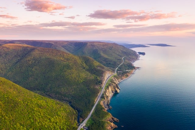
Introduction: The Mabou Highlands form a rounded knoll 15 km (9.5 mi) long by 8 km (5 mi) wide reaching an elevation of 335 m (1100 ft) at the north end and 320 m (1050 ft) at the south. Formed of highly erosion-resistant, metamorphosed sedimentary and volcanic rocks, the surface is highly dissected and the sides deeply eroded. Many trails in the Mabou Highlands are quite challenging, requiring strenuous climbs to reach the best viewing sites.
These same Mabou Highlands were also once the home of many industrious Scottish families, who cleared the hills and grazed sheep on their grassy slopes. Now, save for a few cottages, the area lies mostly deserted and forest has reclaimed the ravines. The former cart tracks connecting long abandoned farms have become a network of challenging trails, courtesy of the volunteer Cape Mabou Trail Club. By 1998, twelve different trails totalling more than 30 km (18.75 mi) of maintained paths were available.
Cautionary Notes: Wildlife. Hunting permitted. Steep climbs. Motorized vehicles in some sections. Poison Ivy. Cell Phone reception is generally available at higher elevations. No reception ravines, under thick foliage, and on most inland sections.
Ratings are designated from 1 to 5 indicating suitability for all fitness and experience levels, with 5 being suitable only for experienced and very fit outdoor people. Novices should only choose level 1 and 2 hikes, and work their way up. Level 4 and 5 hikes have indicators associated with their ratings.
Region: Canada’s Musical Coast
Community: Inverness
The Inverness County Centre for the Arts is a regional hub for the arts on the west coast of Cape Breton Island, Nova Scotia. Situated in t...

Region: Canada’s Musical Coast
Community: Inverness
Welcome to Cabot Discovery Tours, your premier tour operator on Cape Breton Island, where every journey is an adventure and every destinatio...

Region: Canada’s Musical Coast
Community: Mabou
A spectacular ocean view and a warm welcome await you at Ann Schroeder’s home studio. Ann’s fine art quilts, mixed media painti...
Region: Canada’s Musical Coast
Community: Mabou
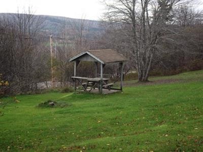
Mabou Provincial Park is 1.5 km (1 mi) north of Mabou (11935 Highway 19) on Cape Breton Island. Its hillside location with picnic ...

Region: Canada’s Musical Coast
Community: Mabou
Nestled in the rolling hills of Inverness County on beautiful Cape Breton, this world-class professional theatre has played host to internat...
Region: Canada’s Musical Coast
Community: Port Hood
Come experience our retail shop, take a hop through our field-grown fruit and vegetable garden, and view and hear the stories of our time at...
June on Cape Breton Island is when music fills the air, feet find rhythm on wooden floors, and communities come together in celebration of culture, heritage, and shared joy.
If you're searching for a beautiful hiking destination on Cape Breton Island, look no further than the trails of Cape Mabou. Located on the Island’s west coast, Mabou is a charming rural community known for its Gaelic culture, coastal views and unfor
Canada's Musical Coast, nestled along the western shores of Cape Breton Island, offers some of the most breathtaking sunsets in the country.
Snowmobiling offers exhilarating experiences across winter landscapes, but safety must always be a priority.
Atlantic lobster from Cape Breton Island is renowned for being the freshest and some of the tastiest lobster in the world.
Tap your toes to fiddle tunes at a Ceilidh. See authentic Acadian crafts at Les Trois Pignons. Take a piece of Mi’kmaq culture home with you at a drum-making workshop. On Cape Breton Island, culture is all around you just waiting to be explored!
When the adventurous duo Chris and Jan from A for Adventure received the call to explore Cape Breton Island’s magical Waterfall Season, they packed their gear, laced up their boots and set their sights on some of Nova Scotia’s most breathtaking scen
Cape Smokey offers a ski experience that’s both easy to reach and impossible to forget. A short, two-hour flight from Toronto lands you right on Cape Breton Island, where you’ll find incredible coastal scenery, fresh powder, and the chance to ski ju